Hole in the Clouds
May 24, 2010
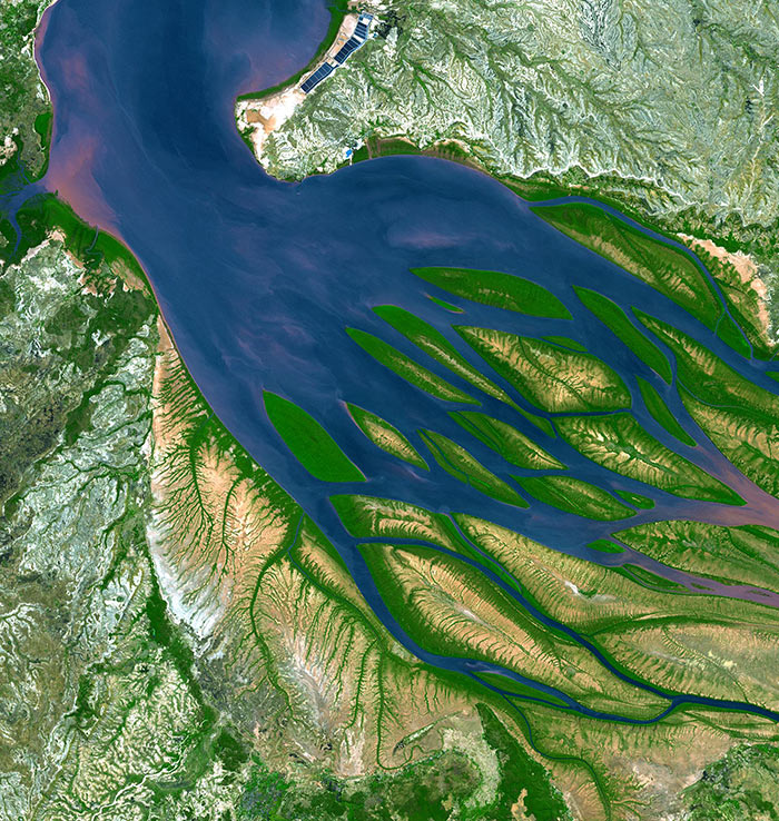
The Bestiboka River reaches the sea in the Mozambique Channel, along the northwestern coast of the island of Madagascar. There at the mouth of the river, ocean tides push saltwater upstream, slowing or even halting the downstream flow of the muddy river water; wherever the river pauses, sand and silt drop to the bottom of the bay, piling up into sandbars and islands.
In Madagascar's tropical climate, new sandbars quickly acquire a fringe of bright green mangrove scrub, which stabilizes the sediment and also shelters baby shrimp and other aquatic critters. Bombetoka Bay, the estuary here, is highly productive, especially for shrimp. The rectangular pens near the top of this picture are commercial shrimp farms.
The mangrove swamps along the lower reaches of the river trap vast quantities of sediment pouring down from upstream, which keeps the water clean and free of mud as it enters the bay; without this mangrove filtering, Madagascar's huge coral reefs just offshore (off the top edge of this picture) would soon die, smothered by sand.
birdseye view
Madagascar
satellite imagery
remote sensing
Bombetoka Bay
(Image credit: NASA ASTER satellite)
Nov 18, 2010
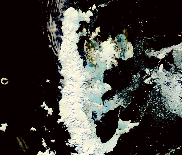
As winter descends upon us in the northern mid-latitudes, the summer sun is beginning to bake the Antarctic peninsula, which angles northward from the Antarctic continent toward South America. This part of Antarctica has warmed up substantially in recent years and is currently shedding its sea ice.
When Sir Ernest Shackleton approached this peninsula during a polar expedition about a century ago, his ship was trapped by sea ice and held fast for more than two years, before being crushed to splinters. In today's climate, a ship could sail freely throughout most of the peninsular region--and it's still springtime in Antarctica, not quite full summer yet.
This picture was taken two days ago by a circumpolar satellite. It shows a few bits of bare brownish ground and several large blue patches, which represent weakened sea ice flooded by meltwater. Relatively warm westerly winds have been breaking up the ice cover and blowing bergs and mini-bergs eastward out to sea.
At the left edge of this picture is a horseshoe-shaped island that is probably a volcanic crater. The Antarctic Peninsula is a mountain range, with peaks and ridges that poke up above the waters of the Southern Ocean. These mountains have been snow-covered for tens of thousands of years, but tune in later this winter/summer to see if we can catch a glimpse of newly naked land hereabouts.
ice
Antarctica
(Image credit: NASA ASTER satellite)
Jun 9, 2011
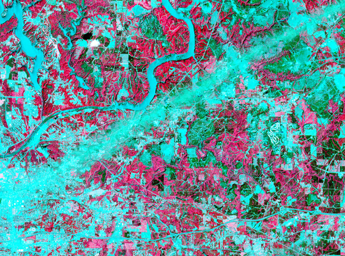 On April 28, 2011, the visible-light and infrared sensors of NASA's ASTER satellite captured this image of Tuscaloosa County, Alabama, which had been raked by an especially large and powerful tornado just the day before.
Infrared sensors are useful for distinguishing between vegetated and non-vegetated land cover. The pink areas in the photo represent vegetation–forests, pastures, cropland, golf courses. Areas that show up as aqua are non-vegetated or very lightly vegetated–cities, highways, rivers, strip mines, recent clearcuts.
The tornado track is obvious here: a straight aqua-colored streak running from the southwest to the northeast. Vegetation in this streak that was not directly destroyed by the storm was so littered with pieces of buildings and household objects that satellite sensors could barely detect it.
Just north of the storm track is the twisting course of the Black Warrior River, which shows up in aqua. The city of Tuscaloosa is mostly south of the river, at the left edge of the picture. In the upper left corner of the picture is Lake Tuscaloosa, a dammed-up tributary to the Black Warrior that provides the city's drinking water.
NASA's spokespeople assert that images such as this one can be useful in the aftermath of storms. They may help identify storm-damaged places outside of populated areas, where tornadoes might escape public awareness. And by proving the time and location of tornado paths, they could help homeowners support their insurance claims for storm damages.
If you click on the picture to see the larger version, you can follow numerous roads out into the countryside and observe that many of them seem to end with a little dot of aqua, indicating a non-vegetated spot. These are well pads for methane rigs. About fifteen years ago, the Black Warrior basin was the scene of one of the nation's first methane gas drilling booms. Coalfields underlie much of west Alabama, including almost all of Tuscaloosa County, but until recently the methane gas associated with coal deposits was considered a danger rather than an economically valuable fuel. "Fracking" technology, in which high-pressure liquids are injected deep into the earth to crack open the rocks hosting methane, was developed and refined in Alabama; drilling for methane is now under way all over the world. Unlike oil or traditional natural gas, methane is best extracted by small wells located within a few hundred feet of numerous other small wells; thus, the countryside is speckled with hundreds or thousands of separate well pads.
Tuscaloosa
Alabama
birdseye view
infrared
satellite imagery
tornado
methane
fracking
(Image credit: NASA ASTER satellite)
(h/t: Chuck Horowitz


