Hole in the Clouds
Aug 3, 2009

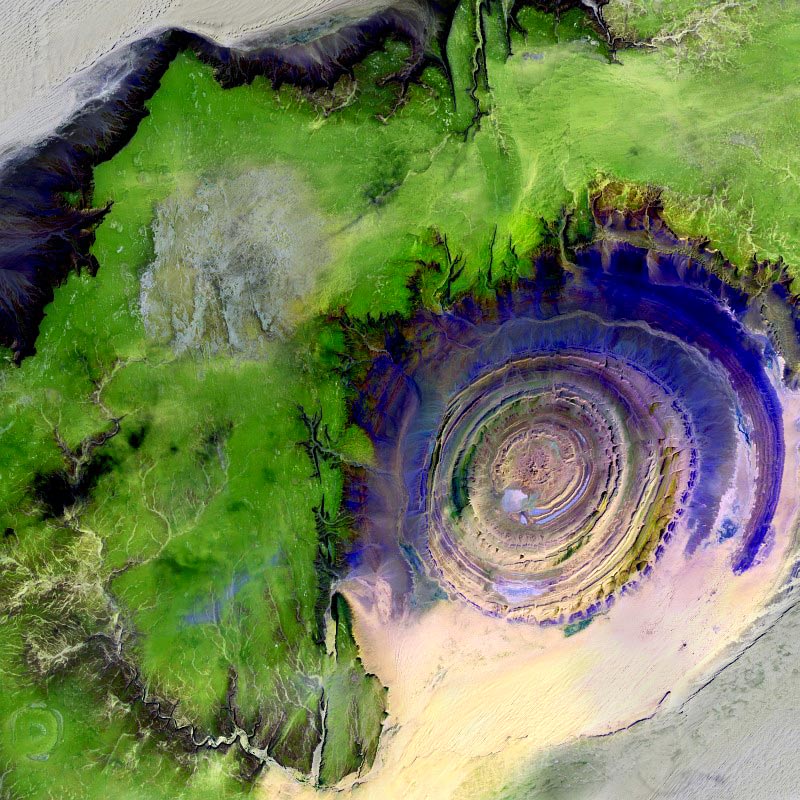
This rock formation, known formally as the Richat Structure and widely as the Eye of Africa, sits at the southern edge of the Sahara desert in Mauritania. It's a favorite of the astronauts looking down on us, and also a favorite of students of Landsat satellite imagery. It's not a meteor crater or a volcano, but a sedimentary rock formation, layer upon layer of tough, resistant sandstone, brought into sharp relief by softer mudrock that is eroding away. The reason for its perfectly round shape is . . . not well understood.
This image incorporates infrared energy as well as light from the visible spectrum, so the colors are not natural. But twhen the sun is shining on the Sahara Desert as the astronauts sail above it, they do see the Eye of Africa as blueish.
Richat Structure
Mauritania
infrared
(Image credit: NASA Landsat 7)
Jun 9, 2011
 On April 28, 2011, the visible-light and infrared sensors of NASA's ASTER satellite captured this image of Tuscaloosa County, Alabama, which had been raked by an especially large and powerful tornado just the day before.
Infrared sensors are useful for distinguishing between vegetated and non-vegetated land cover. The pink areas in the photo represent vegetation–forests, pastures, cropland, golf courses. Areas that show up as aqua are non-vegetated or very lightly vegetated–cities, highways, rivers, strip mines, recent clearcuts.
The tornado track is obvious here: a straight aqua-colored streak running from the southwest to the northeast. Vegetation in this streak that was not directly destroyed by the storm was so littered with pieces of buildings and household objects that satellite sensors could barely detect it.
Just north of the storm track is the twisting course of the Black Warrior River, which shows up in aqua. The city of Tuscaloosa is mostly south of the river, at the left edge of the picture. In the upper left corner of the picture is Lake Tuscaloosa, a dammed-up tributary to the Black Warrior that provides the city's drinking water.
NASA's spokespeople assert that images such as this one can be useful in the aftermath of storms. They may help identify storm-damaged places outside of populated areas, where tornadoes might escape public awareness. And by proving the time and location of tornado paths, they could help homeowners support their insurance claims for storm damages.
If you click on the picture to see the larger version, you can follow numerous roads out into the countryside and observe that many of them seem to end with a little dot of aqua, indicating a non-vegetated spot. These are well pads for methane rigs. About fifteen years ago, the Black Warrior basin was the scene of one of the nation's first methane gas drilling booms. Coalfields underlie much of west Alabama, including almost all of Tuscaloosa County, but until recently the methane gas associated with coal deposits was considered a danger rather than an economically valuable fuel. "Fracking" technology, in which high-pressure liquids are injected deep into the earth to crack open the rocks hosting methane, was developed and refined in Alabama; drilling for methane is now under way all over the world. Unlike oil or traditional natural gas, methane is best extracted by small wells located within a few hundred feet of numerous other small wells; thus, the countryside is speckled with hundreds or thousands of separate well pads.
Tuscaloosa
Alabama
birdseye view
infrared
satellite imagery
tornado
methane
fracking
(Image credit: NASA ASTER satellite)
(h/t: Chuck Horowitz
Jul 9, 2011
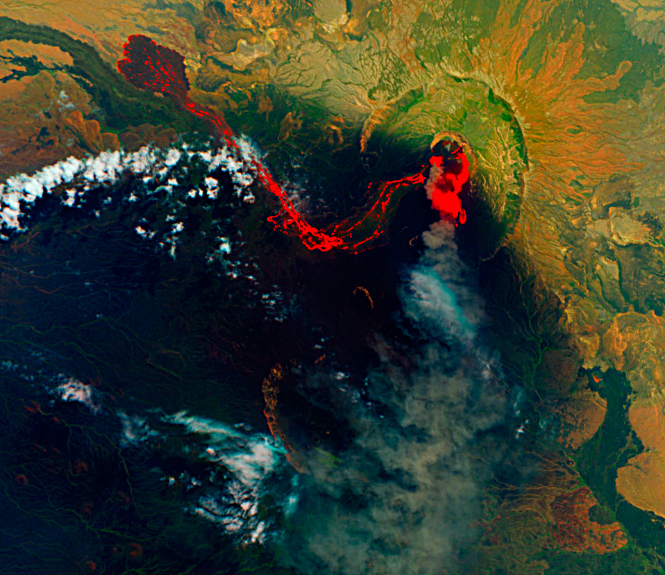
 About three weeks ago, the Nabro volcano in the East African nation of Eritrea began erupting for the first time in recorded human history. The initial eruption was a violent explosion, pumping vast quanitities of ash and sulfur dioxide into the air above North Africa and the Middle East. Aviation in the region was briefly suspended. Nabro's dark, dense plume of ash and gases shrouded the mountaintop for two weeks, concealing the eruption from view until June 29, when this satellite image was captured.
The image shows that the eruption has transitioned to a quieter, oozing sort of phase. Hot lava glows orange, fading to black as it cools. The lobes at the end of the long lava flow are dark, suggesting that the top of the flow may have crusted over. As the long westward flow cools, hotter, fresher lava appears to be spilling out of the vent toward the south and east.
Nabro is in very arid, dusty country; the green patches in the landscape around the volcano are actually only sparsely vegetated. The image was captured using a combination of infrared and visible light, which misrepresents the degree of vegetation in the landscape.
Although the eruption is a first for the record books, Nabro is in the East African rift valley, where volcanic activity in one form or another is nearly constant. Three tectonic plates are pulling apart from one another in this region, stretching the earth's crust so thin that hot magma from deep below finds numerous weak spots through which to erupt.
birdseye view
infrared
volcano
satellite imagery
Eritrea
Rift Valley
Nabro
(Image Credit: NASA–EO1)
Dec 1, 2011
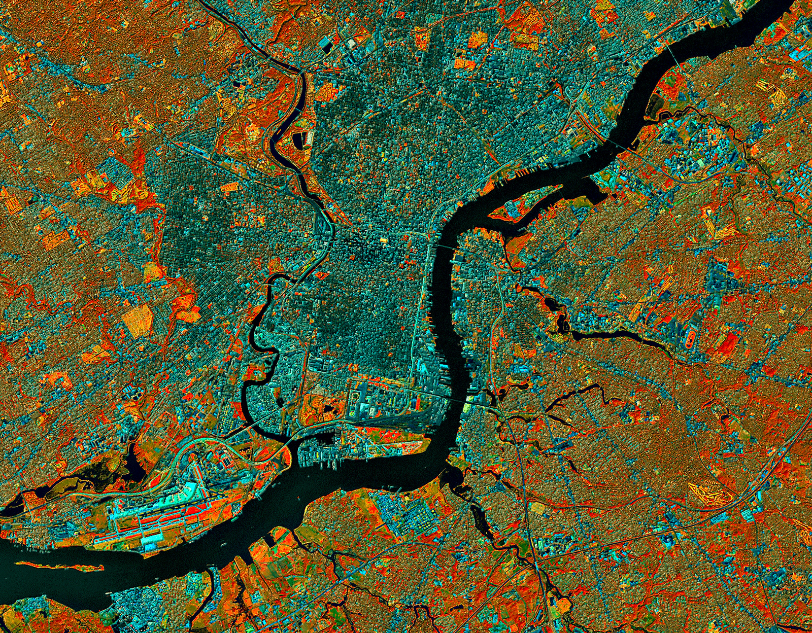
 At about 9:30 in the morning on September 23, 1999, the Landsat 7 satellite swooped southward over eastern North America and captured this image of Philadelphia and environs.
Three of the Landsat sensors detected energy in the infrared part of the electromagnetic spectrum, completely invisible to the human eye. Data from these sensors is displayed here, with each of the three infrared bands assigned to one of the normal red-green-blue color bands so we at least have something to look at, even though the colors have nothing to do with normal vision.
Clicking on the picture brings up a bigger version, which shows much more detail.
We can tell right away that the rivers are black; infrared energy is completely absorbed by water, reflecting back nothing for the sensors to detect. And if we look along the river at lower left, we can make out the airport, with runways that are bright cyan in color. This white-to-bluish hue is also the color of roads, railroads, parking lots, and other paved surfaces.
Infrared data is especially useful for studying vegetation, which shows up in this color scheme as red, orange, or yellow. The brightest red patches represent vigorous herbaceous growth, such as healthy cropland in the midst of the growing season. There's little or no farmland in and around Philly, however, so the red patches we see here, such as in between the airport runways, are probably healthy weeds.
Patches of red coloration with a touch of an orange tint and some texture are forested areas, such as in parks or between the fairways of golf courses. Extremely vigorous grass, such as on the golf course fairways themselves, looks bright yellow in this view.
The brownish-to-grayish-to-bluish areas show mixed land cover: Landsat's sensors are averaging out the infrared signals from house roofs, pavement, lawns, shrubs, and trees in varying concentrations. Brownish areas are suburban, with lots of trees and grass; dark green to gray-blue areas are more urban, with a higher ratio of rooftops and pavement to vegetation.
Philadelphia has changed since this image was captured twelve years ago. Another stadium has been built near where the Schuylkill River empties out into the Delaware. In my neighborhood just south of Center City, the forested patch of land near the Schuylkill, which in 1999 was an abandoned and overgrown Old Sailors' Home is now a heavily developed condo complex. Even though the population of Philadelphia has shrunk dramatically over the past half-century and has just barely started growing again, land use patterns as viewed from outer space show ongoing urbanization.
Pennsylvania
birdseye view
infrared
Philadelphia
city
airport
Landsat
bands 457
rivers
refinery
(Image credit: NASA Landsat 7)
Dec 9, 2011
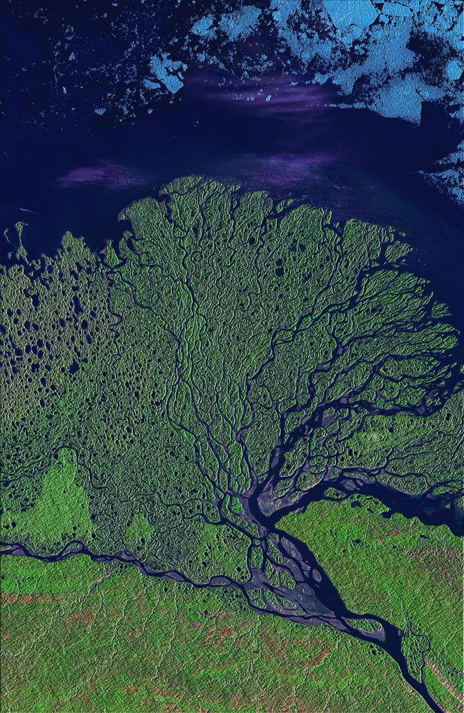
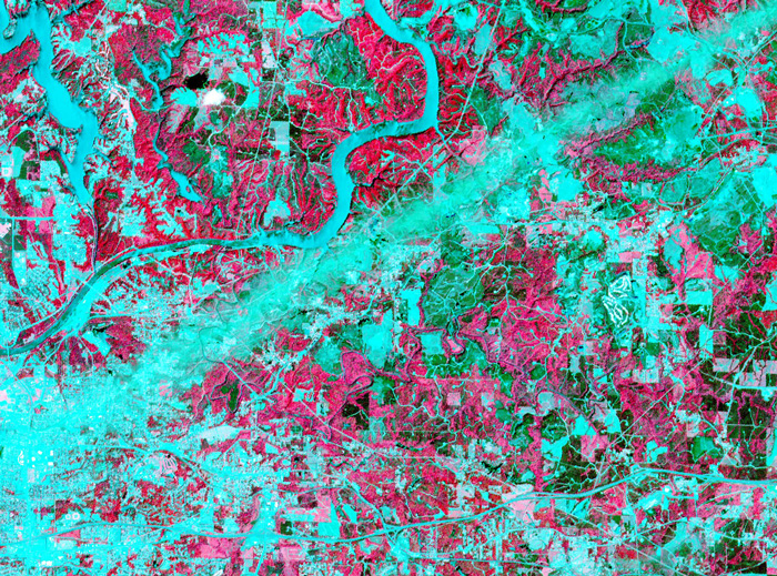
The satellite view of Philadelphia in infrared, from a few days ago, led some people to ask for more false-color imagery of our planet. Here we've got a river delta in the tundra of eastern Siberia, where the River Lena empties into the Arctic Ocean. The image is from mid-summer, when the plants of the tundra were bursting with new growth, thanks to twenty-four hours a day of sunlight. The color scheme here is different from that of the Philadelphia scene but still not closely related to the colors a human eye would detect. The data displayed comes from three sensors on the Landsat satellite: one that detects infrared energy, another that detects near-infrared energy, which is very sensitive to the chemicals associated with growing vegetation, and a third sensor that picks up a part of the visible spectrum. Vegetation is green, exposed rock or soil is pink, wet soil (mud) is purple, and ice is blue.
Even in mid-summer, the sea ice floats close to shore. It will take another month or two for most of the ice to melt and/or wash out to sea, but as soon as it does freezing temperatures will return and ice formation will begin again.
The innumerable ponds and distributary streams are typical of flat places throughout the Arctic tundra, where permafrost just below the surface impairs drainage. Meltwater and rainwater sit on top of the permafrost all summer long, breeding mosquitoes...... which don't show up in the satellite imagery.
birdseye view
Russia
infrared
Siberia
remote sensing
tundra
Landsat
Lena River
delta
river
Arctic Ocean